
Josvainiai Forest
| Josvainiai Forest Lithuanian: Josvainių miškai | |
|---|---|
 Inside the forest at the surroundings of Keleriškiai | |
| Map | |
 | |
| Geography | |
| Location | Kėdainiai District Municipality, Lithuania |
| Coordinates | 55°19′05″N 23°47′24″E / 55.318°N 23.790°E |
| Area | 31.1 km2 (12.0 sq mi) |
| Ecology | |
| Forest cover | birch, spruce, aspen |
| Fauna | wild boar, roe deer, red fox |
The Josvainiai Forest (Lithuanian: Josvainių miškai) is a forest in Kėdainiai District Municipality, central Lithuania, located 6 kilometres (3.7 mi) to the west from Kėdainiai and 4 km to the north from Josvainiai. It covers an area of 3,110 hectares (7,700 acres). It consists of smaller forests: Josvainiai Forest (proper), Medininkai Forest, Giraitė. The rivers Smilga, Smilgaitis and Tranys drain the forest (the Nevėžis basin).
As of 2005, 52 % of the area was covered by birch, 24 % by spruce, 5 % by aspen, 8 % by ash, 3 % by oak, 3 % by black alder, 3 % by white alder, 2 % by pine tree groups.[1] The fauna of the forest consists of wild boar, roe deer, red fox, raccoon dog, pine marten, as well as hazel grouses, black storks, Eurasian woodcocks, common buzzards, sparrowhawks, northern goshawk, owls.[2] The forest is included in Dotnuva-Josvainiai Biosphere Polygon,[1] also there is the Smilga Landscape Sanctuary in the forest.
During the Soviet era, there was a rocket base (now in ruins) in the forest near Keleriškiai. Barsukynė, Palainiškiai, Čiukiškiai and Stasiūnai, Grašva villages are inside the forest or on its edges.
Images[edit]
-
 Forest nearby Šiukštuliškiai village
 -
 The Smilga River inside the forest
 -
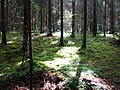 A spruce forest with oxalis acetosella floor
 -
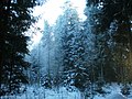 Forest in winter
 -
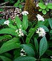 Allium ursinum in the forest
.JPG)


References[edit]
- ^ a b Brukas, Algirdas (2006). Visuotinė lietuvių enciklopedija (in Lithuanian). Vol. 9. Vilnius: Mokslo ir enciklopedijų leidybos institutas. p. 737.
- ^ Brukas, Algirdas (1986). Tarybų Lietuvos enciklopedija (in Lithuanian). Vol. 2. Vilnius: Vyriausioji enciklopedijų redakcija.